The DEP recently released a FAQ addressing what they felt was misinformation about the new Wharton Motorized Access Plan. The only misinformation about the MAP has been provided by the DEP. Here is a step by step analysis of their responses. The DEP’s comments are italicized for clarity.
What is the Wharton State Forest Motorized Access Plan?
The Wharton State Forest Motorized Access Plan is designed to make the many activities available in the Forest accessible to visitors driving on-road motor vehicles, while also preserving and protecting the Forest’s precious and irreplaceable natural environment.
The Plan includes a detailed map that shows the 225 miles of open roads within the Forest and informs both first-time and long-time visitors to the park of the many opportunities to enjoy this beautiful and unique environment.
The claims that the Wharton MAP improves access to the forest is a blatant lie. Over half of the roads and trails in Wharton State Forest are being closed to motor vehicles, preventing users of the forest – most of whom have no interest in “four wheeling” – easy access to places that they have historically been free to roam. While some roads and trails have been damaged by irresponsible off-road vehicle use, the MAP provides no plan for the enforcement of these road closures. Without effective enforcement those who would carelessly damage the forest’s precious and irreplaceable natural environments would be free to continue their destruction while the overwhelming majority of the forest’s users would be closed off from huge swaths of public land.
Why is the State Park Service implementing this Plan?
The State Park Service is implementing this plan to ensure wide and safe access to the Forest while also ensuring that the Forest is protected for today’s visitors and future generations.
The funding for developing this plan was provided by the federal government to promote better access to the Forest for on-road motor vehicles and to protect the safety of the many visitors using the park on foot, bicycle, or horseback.
The DEP has implemented the MAP unilaterally and without the opportunity for public comment. As a result of this back alley deal roads have been marked closed prior to any public announcement being made. The DEP had planned to wait until the end of the summer to announce the MAP, after it had closed many trails, but were forced to move the announcement forward to perform damage control over the widespread outrage at the secrecy of the closures. Their secrecy has been so complete that even elected officials in Trenton have been unaware of this plan.
The funding for the plan came from the Recreational Trails Grant Program, a Federal Highway Administration program designed to provide provide funds to states looking to develop and maintain recreational trails and trail-related facilities for both motorized and non-motorized recreational trail uses. Funding for the program is provided by federal taxes collected on gasoline. Interestingly, the State’s grant application makes no mention of road closures at all. Had they done so it is possible that the grant would not have been awarded.
What will the Wharton State Forest Motorized Access Plan accomplish?
The new Motorized Access Plan will:
- Promote responsible recreation in the Forest.
The overwhelming majority of the visitors of Wharton State Forest use the road and trail system responsibly. These people will be disproportionally punished by the implementation of the MAP. Roads and trails that have been open for public use for decades, if not centuries, are now suddenly closed with no warning given.
- Increase awareness and interpretation of the impacts motorized recreation can have on the Forest resources.
It’s true: The MAP brochure shows some pretty grim images of off-road devastation which are totally inflammatory and do not represent the impact that the majority of the people who drive on Wharton’s sand roads and trails have.
- Improve stewardship and protection of the natural and cultural resources in the Forest.
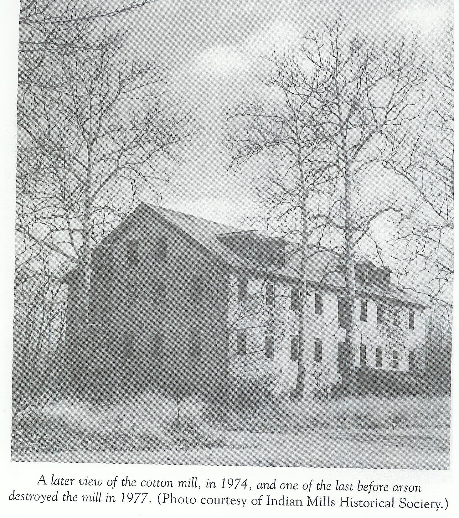
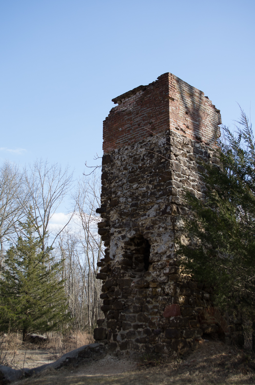
One of the DEP’s jobs is to provide stewardship and protection of the natural and cultural resources of the forest. This would be the case even if the MAP was not implemented. As far as stewardship of the forest goes, there are many main roads that have been ill-maintained for years, and many historic buildings such as cotton mill at Atsion or the entire ghost town of Friendship have been lost from neglect or arson due to the state’s particular brand of “stewardship.”
- Focus maintenance efforts on the designated routes.
The roads that are left open are all “main” roads through the forest that should have always been adequately maintained.
- Promote access to new visitors.
This is one success story of the MAP. A map showing all of the roads and trails through Wharton, in even greater detail than the somewhat outdated USGS topographic maps of the area, would help guide both new and old visitors safely throughout the forest. Road closures are not necessary to help guide those visitors.
- Improve coordination and access for emergency response including forest fires, search and rescue operations and severe storm response.
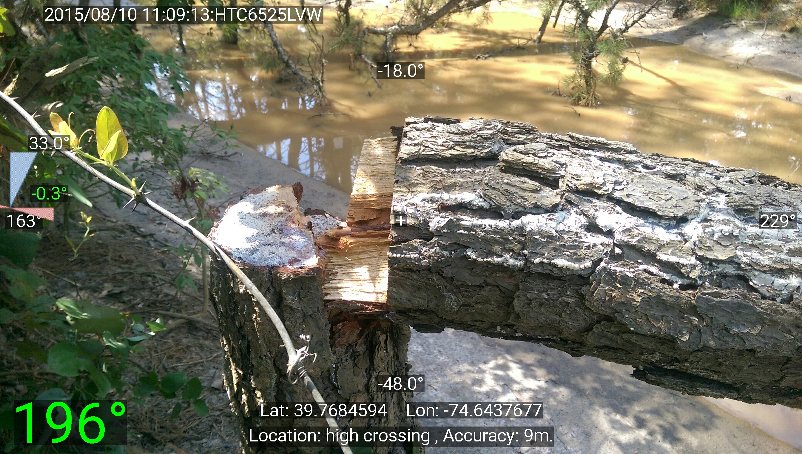
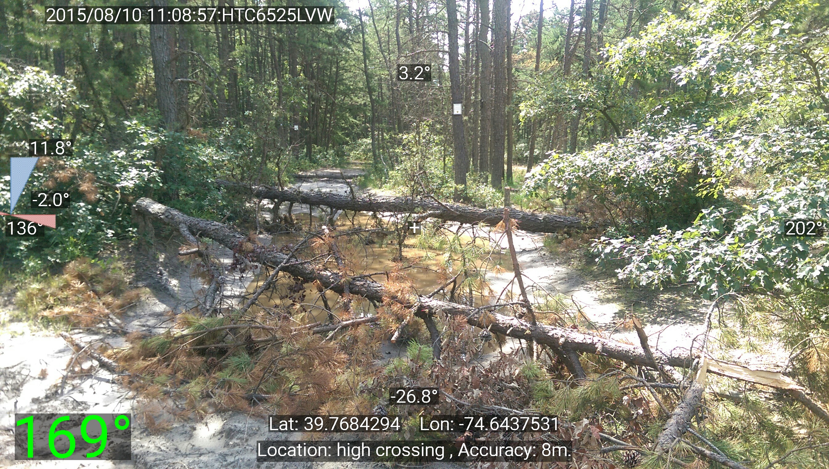
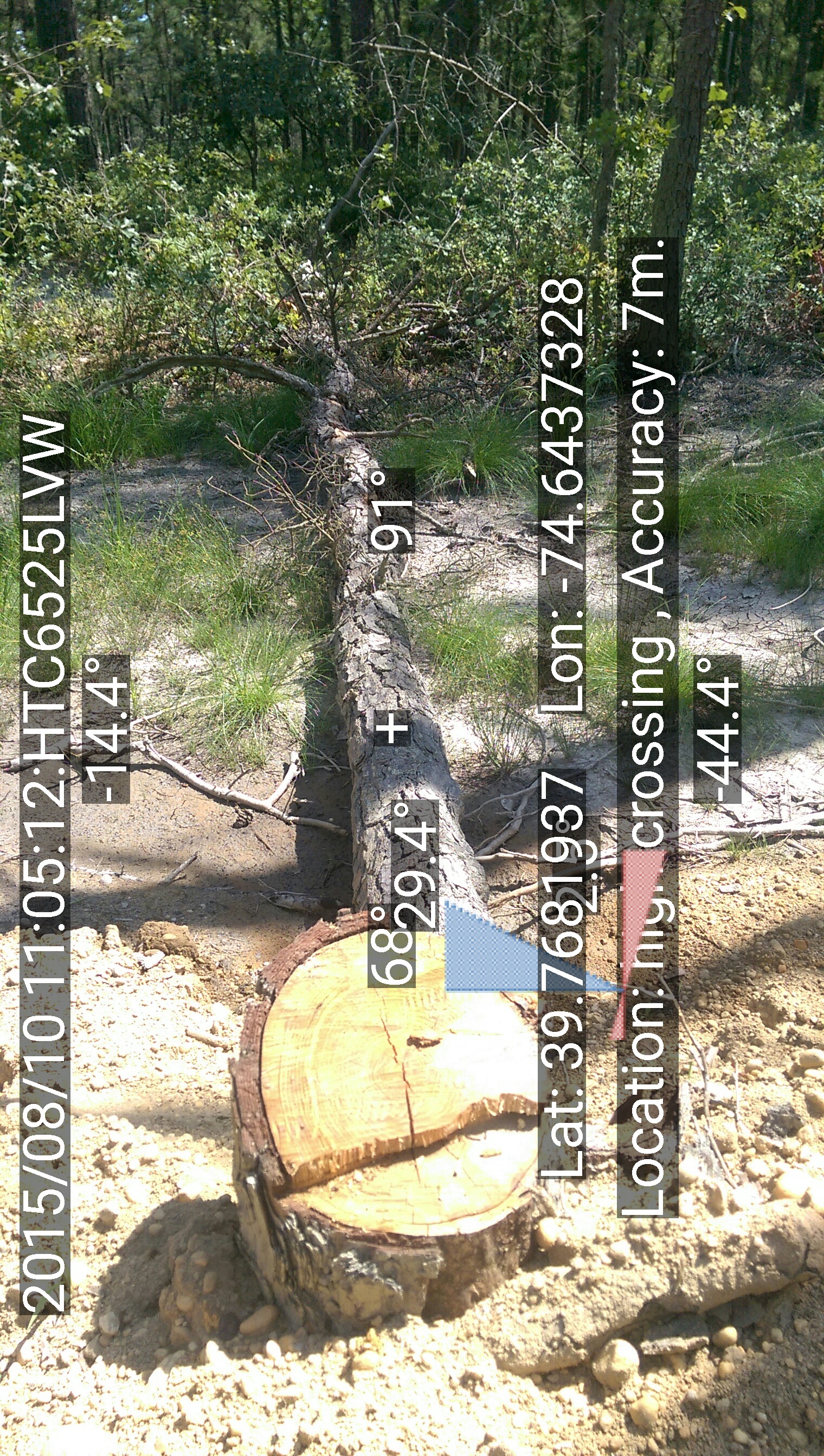
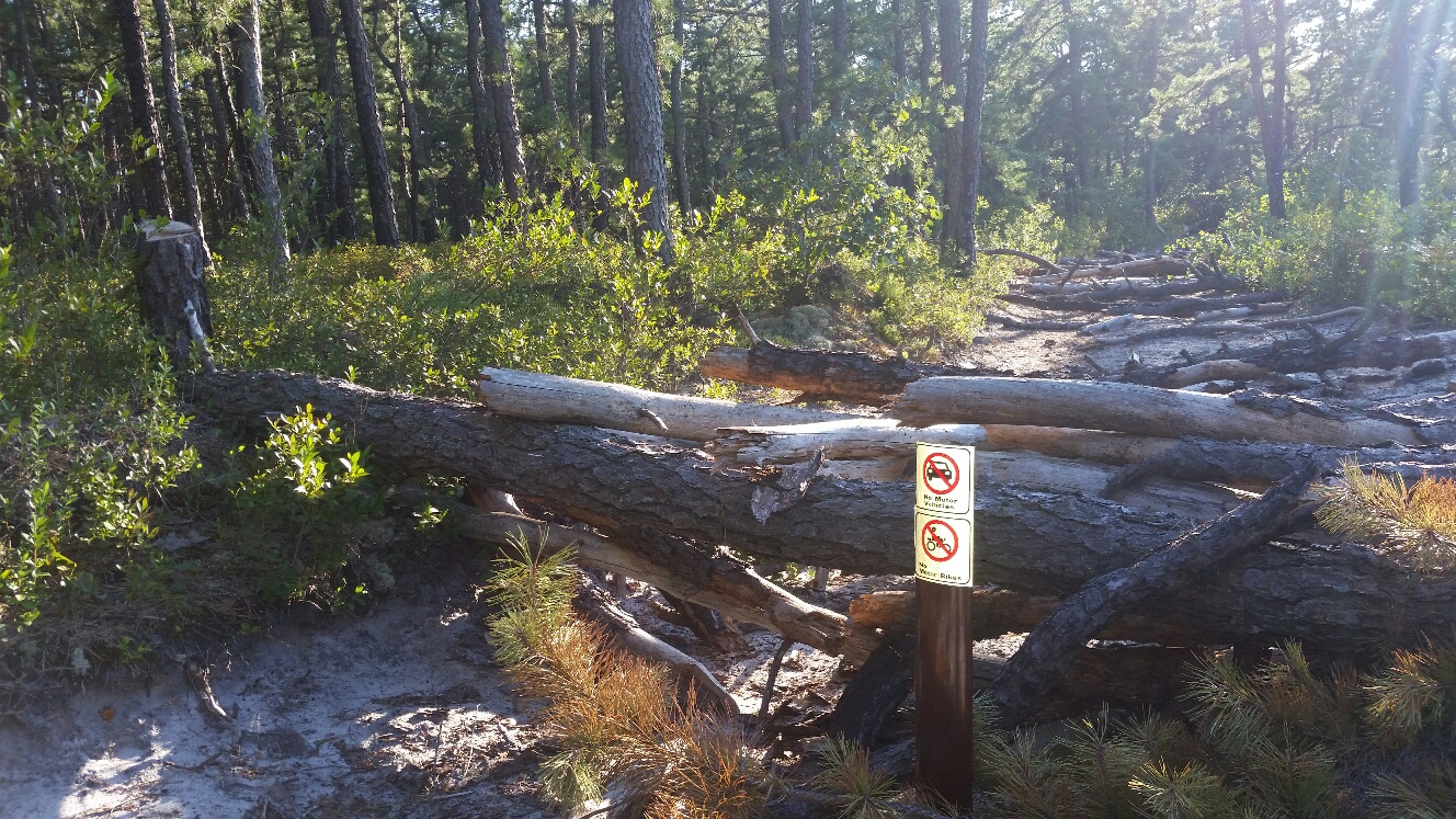
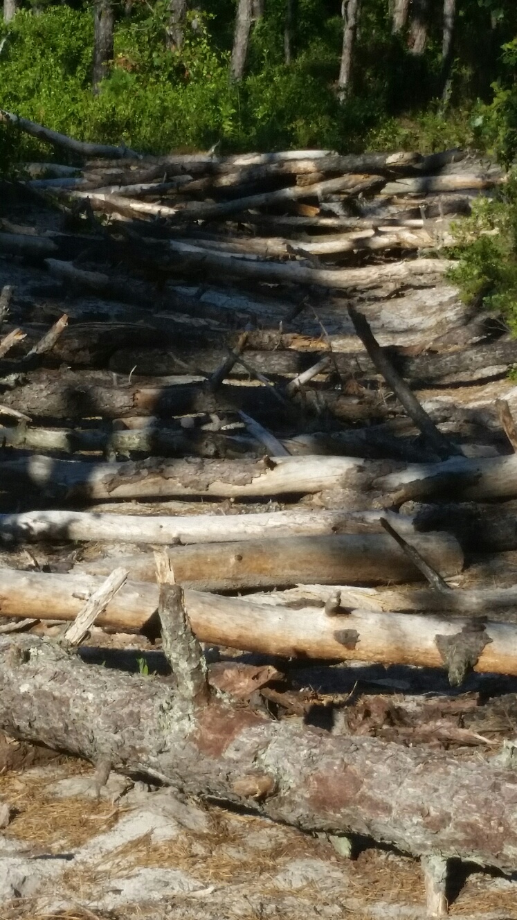
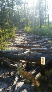
The state has been closing some roads by barricading the way with freshly cut or dead fallen trees. Far from allowing swift access for emergency first responders, the crews will be held up. They will be losing valuable time clearing fallen trees from the road during a potentially life-threatening emergency.
- Streamline and coordinate education and enforcement efforts.
The Wharton MAP makes no provisions for either education or enforcement efforts.
How many miles of roads are open for on-road motor vehicles under the new plan?
Approximately 225 miles of routes throughout the Forest will be OPEN for public motorized access. That is equivalent to almost twice the length of the New Jersey Turnpike. The majority of all roads within the Forest will remain open for public motorized access.
The fact that the mileage of the roads left open in Wharton is twice the length of the turnpike is irrelevant. Just as you’re not going to develop a true appreciation for the pinelands by driving through it on the parkway, you won’t get the sense of the wonder that the Pine Barrens has to offer on the wide, crowded sand roads that are now the only ones left open to the public. Remember, over 50% of the existing roads and trails have been CLOSED for public motorized access. Those roads, already crowded, are going to get much worse.
How is this new Plan different from previously designated motorized access within Wharton State Forest?
The majority of all routes that have been designated for motorized public use in the past will remain open to public motorized access. See attached maps from 1997 and 2003. They are very similar.
There has never been a public announcement stating what roads and trails were designated for motorized vehicles in the history of Wharton State Forest. Previously, road closures were small, targeted, and adequately marked with signage. The maps that the DEP’s FAQ refers to are maps that have been handed to people reserving campsites and only show various “unimproved sand roads” due to their small scale. Those maps were never intended to be used as a road map to show what areas were open or closed.
Are the non-designated routes (or dotted lines) on the M.A.P completely closed to the general public?
No. All non-designated routes will remain open to foot traffic, horseback riding and bicycling.
True, provided that the road you’re looking to travel down has not been physically barricaded with obstacles.
How will this plan affect my ability to get to my favorite locations within Wharton State Forest?
No part of the 125,000-acre Wharton State Forest is more than about one mile from a paved road or a sand road that is designated “open” to on-road motor vehicles under the M.A.P.
That might be true, but that mile that you have to traverse to get to a spot that was once conveniently located next to a road might now lie behind a mile of tangled briars, an impassable cedar swamp, or a river that would be dangerous to ford. Plus, if you were a kayaker looking to launch at your favorite secluded spot, or a photographer laden down with heavy gear, how feasible is it to bushwhack a mile or more through the woods to get to a spot that once was easily accessible? Not to mention the risk of exposure to poison ivy and disease carrying insects increases the more time you spend crashing through the forest getting to where you need to go.
Will I still be able to drive to historic sites in the Forest?
Yes. The M.A.P. directs visitors to many sites of historic significance throughout the Forest.
The majority of the “touristy” historic sites such as Batsto, Atsion, and Harrisville are all reachable via paved state or county roads. Reaching the more obscure historic sites that were already difficult to reach will now require a lot more effort.
Will I still be able to drive to kayak and canoe launch sites in the Forest?
Yes. The M.A.P. directs visitors to designated kayak and canoe launching sites throughout the Forest. Parking is available at the Forest’s launch sites that are accessible by motor vehicle.
Will disabled visitors have access to the Forest?
The Americans with Disabilities Act and the State Park Service policy regarding Use of Mobility Devices will ensure disabled visitors can access the Forest.
The wording of this is too vague. How exactly does the MAP make provisions for park visitors protected by the Americans with Disabilities Act?
Can I bring my ATV on these designated routes?
No. ATVs are not permitted on any lands administered by the State Park Service.
Every day there are dozens of ATVs buzzing through the forest due to the lack of enforcement by the state. The MAP makes no provisions to address this.
Will approved enduros continue to be permitted in the State Forest?
Yes. Enduros will continue to be permitted by authorizing one-day Special Use Permits. This Plan will not change the present Enduro Management Plan and the SPS policy regarding Organized Competitive and Recreational Motorized Vehicle Events and Activities.
In recent years the DEP has made the process of obtaining those special one-day Special Use Permits an increasingly arduous task. Just as the DEP has waged war against the enduro riders (a group who have been holding events in Wharton State Forest since the 1960s) they now are waging war against vehicular access. What group will be the next target?
Will Forest Firefighters or other emergency responders still have access to the Forest?
Yes, in fact the Plan will improve emergency response. Focused maintenance and repairs will facilitate quicker response time, access, and safety for first responders. A secondary and key benefit of the M.A.P. is that these designated routes are also primary fire breaks, thus also improving access to first responders.
Another bald faced lie: The State is actively placing physical barriers on some of the closed roads, making it difficult if not impossible for emergency crews to access roads in time critical situations.
The designated routes on the MAP, roads that have been there for centuries in some cases, have always been fire breaks. The MAP does not provide any additional protection for forest fires – in fact it hinders them.
Was a new law passed to allow this Motorized Access Plan to happen?
No, the NJ State Park Service Administrative Code has long authorized the prudent control of motorized vehicles on state lands.
In 200s DEP Commissioner Bradley Campbell prohibited the use of Class II ORVs (quads, dirt bikes, etc. – anything that was not street legal in New Jersey) on state owned land. As a “concession” to the users of those vehicles the state was tasked with building two new off-road vehicle parks to provide a safe, controlled environment where those vehicles could be used. Fourteen years later there has only been one park opened, and even that one is currently closed.
The DEP knew that their “concessions” would make it easier for this plan to be approved but they knew that it would be a herculean effort to get those parks built to accommodate the users that were thrown out of the forest. Now the off-road vehicle ban is extending to all Class I ORV’s (any car, truck, or SUV legally allowed to operate on the street). What fake “accommodations” will the state try to make here?
The only sane, fair control of motorized vehicle access on state lands are the targeted closures that have appeared here and there in the forest. These have been marginally effective, but a lack of enforcement has still allowed people to enter and abuse those areas.
Where can I find the map online?
Please visit the Wharton State Forest webpage at http://www.njparksandforests.org/parks/maps/wsf_motorized_access_plan.pdf to view the entire M.A.P.
When the MAP first appeared online it did not have the label “draft” on it like the one linked from the official Wharton State Forest website which that link does not point to. This is another half baked attempt at the DEP’s damage control. Make no bones about it, that “draft” map is the final product.
Will stakeholders have a chance to express their views about this plan?
Yes, a series of meetings are being scheduled. The first ones are anticipated to occur in September 2015. These meetings will provide representatives of various stakeholders and user groups with a detailed presentation regarding the M.A.P. and an opportunity for feedback.
It’s important to note that the Wharton MAP has been designed and approved without the input of the stakeholder groups. Now that there has been widespread outrage at the plan and legislators now questioning it the DEP is interested in meeting with certain “stakeholders.” It seems unlikely that, after spending hundreds of thousands of dollars to implement the MAP, the state would incur the cost of changing the plan which would show that the DEP’s actions were a waste of grant money.
How can I get notice of when the stakeholder meetings will take place?
Invitations will be sent out to the stakeholder groups. Leaders of interested organizations that use the Forest should contact the State Park Service at (609) 704-1964 to be sure they are included.
Where can I send my comments on the M.A.P.?
Individuals can send their comments to whartonmapcomments@dep.nj.gov.
Those interested in fighting against the MAP implementation are better served by signing the petition against it. It’s important that your elected officials know your feelings, rather than have them be ignored by the people monitoring that email address.
You should also take a look at Open Trails NJ (also on Facebook), a group dedicated to the public’s fair access to State land.
Is this M.A.P. ever going to change? Will more roads/routes be opened?
Yes, this M.A.P. is a work in progress. The State Park Service will continually evaluate the effectiveness of the M.A.P. to ensure that it meets the goals of promoting access to the Forest and preserving and protecting the Forest’s environment.
It seems unlikely that, once a road is closed, it would ever reopen. There are no formal provisions for determining under what a criteria a road might be reopened. If anything, additional closures are probably the only changes to the MAP.
Will the State Park Service be blocking non-designated motorized recreation routes with trees, guardrails, gates, or other barricades?
No. Many areas may be posted with appropriate signage but access will remain open for enforcement, first responders, forest fire personnel, and other permitted uses.
This is a lie. The State has already blocked several roads and trails with fallen trees.